
Increasingly, we draw on digital information identifying the geographic location and characteristics of the places in which we live and travel. This type of data grows more valuable when used to compare different time periods. For example, it can provide answers to basic questions such as, How have the streets in a given county changed over the past five or 10 years? or, How has a large coastline area eroded and changed shape over a given period of time? And, there is the now common use of a digital map to find a specific location, anywhere on earth. The information derived from this specialized data is indeed useful on a variety of levels; it’s used by national and local governments, by real estate and other commercial businesses and provided as public information.
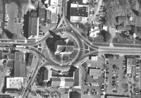
Downtown Pittsboro, North Carolina, U.S.A., from the 1997 Chatham County North Carolina digital orthophotography.
An overview of the key issues and processes involved in this field were demonstrated in an all-day tutorial titled “Preservation Issues Related to Digital Geospatial Data,” held April 21 at the Library of Congress. The National Digital Information Infrastructure and Preservation Program sponsored the tutorial, led by Steve Morris, head of Digital Library Initiatives at North Carolina State University Libraries and co-principal investigator of the NDIIPP-supported North Carolina Geospatial Data Archiving Project.
This was the first such tutorial sponsored by NDIIPP, and it provided a good opportunity to become acquainted with this subject area. In order to make geospatial data usable there are many technical components and complex analyses involved, and a general familiarity with this process is useful for practitioners in the areas of digital libraries, records management and geographical systems, to name a few. In addition to staff members from various units of the Library of Congress, there were also attendees from several other government agencies: the U.S. Geological Survey, the National Archives and the Government Printing Office.
Although he covered a lot of detail during the tutorial, Morris limited his discussion to geospatial data relating to counties and municipalities. He began with the basic vocabulary, tools and techniques that are part of this ever-expanding field. The introduction included a necessary first step -- providing a good definition for a geographic information system, that is, “a system used to capture, store, manipulate, analyze and display all types of spatially referenced geographic information about what is where on the earth’s surface and how they relate to each other.” As for the principal uses of this data, "GIS can be used in a wide range of local government applications such as economic development, tax assessment, management of public utilities and emergency response,” said Morris. “Data produced at the local level can be supplemented with data from state and federal agency sources."
Morris provided an overview of the many different types of geospatial data, including digital maps and aerial photographs, as well as those that display representations of roads and streets, property lines and political boundaries. He also covered the issues of metadata, choosing the right data for the task at hand and geospatial Web services. Morris discussed future directions of the geospatial industry, such as new mapping environments (both online and desktop) and the huge increase in demand for geospatial content and services. In addition to providing this informational overview, Morris showed many images illustrating various uses by state and local governments (such as an image of Pittsboro) and many charts and graphs to indicate statistics and data usage (such as how much for public works, emergency management, etc.)
The second part of the tutorial addressed the major question of how best to preserve this very complex and ever-changing data. Morris pointed out the many risks involved in the retention of geospatial data, such as obsolete formats and data deletion, and that gathering and identifying content need to be done with preservation in mind. He also identified the different ways to approach preservation, which can range from technical solutions such as building data repositories to organizational solutions that would influence data production and serving needs such as disaster preparedness or other pressing business problems.
As part of NDIIPP, the North Carolina Geospatial Data Archiving Project collects and preserves digital geospatial data resources, including digitized maps, from state and local government agencies in North Carolina. Although this project focuses solely on North Carolina, it serves as a demonstration project for other states. For more information, see the project Web site.